New mapping tool makes navigating the Greenway easier than ever

A major rebuild of our online mapping tool, map.greenway.org, makes finding your way on the East Coast Greenway quick and easy. Features of the tool include the ability to find your way to the closest point on the Greenway from wherever you are, to use the map on your computer or as a mobile web app on your smart phone, and to generate turn-by-turn directions and GPX files for mobile navigation devices. (Note: The new tool is not a native app but a web app, meaning you access it through the browser on your phone.)
“We’re excited to introduce this major mapping upgrade,” says Niles Barnes, director of Greenway programs. “Our goal was to improve the user experience and improve the quality of our data. We are seeing a significant uptick in the number of people who want to travel on the East Coast Greenway, and we all want to be able to navigate the route more easily. We knew we had to make this critical investment to improve the Greenway experience.”
Key features of the all new map.greenway.org include:
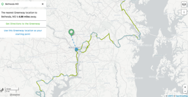
Get to the Greenway from wherever you are.
The new mapping tool allows you to search a starting location and show you the closest point on the Greenway. You can opt to use your default mapping tool (say, Google Maps) to get directions to that point on the route or choose that greenway location as your starting point.
On a mobile device, you can use the locate me feature to identify your location in relationship to the route and to see your movement as you travel along the route.

Map trips from a few miles’ commute to a long-distance ride.
The new tool offers a clean, clear base map (with options for satellite view and city streets view) no matter how far you’re looking to go. Simply choose start and end points and the tool will identify the ECG route, calculate the mileage, and create an elevation profile to show you how much you’ll be climbing and descending. Click on the printer icon to generate turn-by-turn cue sheet directions. (Note: After typing in starting and ending locations, press return/enter, not the search icon.)
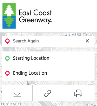
Share your trip map with a friend — or another device.
Once you’ve chosen start and end points and created your map, you can copy the map as a link (choose the link tool) and email it to yourself or friends for later use. Click the download arrow to download GPX files for use on mobile navigation devices like a Garmin. Choose the printer icon to generate turn-by-turn directions that can be saved as PDF or printed off.
The East Coast Greenway Alliance worked with the nonprofit GreenInfo Network to develop this new open source mapping tool.
“We are grateful to the professionals at GreenInfo Network for their hard work developing this interactive map. We also appreciate the many years of mapping support from Steve Spindler, and the assistance from John Branigan for his consultation on our mapping needs,” says Barnes.
“The support of members and funders made this major enhancement possible,” says Dennis Markatos-Soriano, executive director. “We hope you'll check out the tool and give us your feedback. Remember that our technology needs continue to grow and require updates, your support helps fund future mapping enhancements.”
Join the Greenway family
Receive East Coast Greenway news directly in your inbox.
Together, let's grow the Greenway
Recent record-setting funding for design and construction goes directly to building the East Coast Greenway - as it should. The East Coast Greenway Alliance needs your support to continue our advocacy work that is fueling completion of the Greenway. The Alliance has a sustained track record of turning every dollar donated to our nonprofit into $100 in public infrastructure investment. Invest today and support the growth of the East Coast Greenway from Maine to Florida.