South Carolina
Visit the low country, Myrtle Beach and other beach communities, and the charming city of Charleston.
256
59
Current Progress
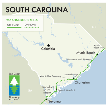
In South Carolina, the East Coast Greenway stays near the coast through the state’s low country, bringing travelers through Myrtle Beach, Georgetown, Charleston, and Beaufort to the Georgia border. Completed trails furthest north include the many trails of Myrtle Beach — the first East Coast Greenway city to complete all of its off-road trail!
Continuing south, three segments of the Waccamaw Neck Bikeway are coming together to offer safe travel through Georgetown County. The route continues on road to Mount Pleasant, where a separated bike/ped path on the Ravenel Bridge over the Cooper River leads travelers to Charleston’s West Ashley Greenway.
In Beaufort, the beautiful Spanish Moss Trail offers over 10 miles of scenic views and Southern hospitality. A paved greenway along SC 170 provides a welcome break from on-road segments between Port Royal and Savannah.
VERY IMPORTANT ROUTE DETAILS: For riders, walkers and runners utilizing the Greenway travel route in South Carolina, please note the following:
While we are working to ensure that permanent, traffic-separated paths will one day connect the length of coastal South Carolina, major gaps exist between existing trails. Traveling those gaps means you will be on stretches of high-speed rural highways that provide no bicycle and pedestrian facilities, including paved shoulders. You will be sharing a travel lane with 55-plus mph traffic for several miles at a time. The segments without dedicated bicycle and pedestrian facilities include:
-
U.S. Highway 17 north of Georgetown, S.C.
-
U.S. Highway 17 north of Mount Pleasant, S.C.
-
U.S. Highway 17 between Jacksonboro and Rantowles, S.C.
-
S.C. Highway 170 north of Okatie, S.C.
Use Google Street View to familiarize yourself with road conditions in these areas. If you cannot avoid traveling these segments, please exercise extreme caution. If traveling with a group, travel together. If your group has a support vehicle, have it follow you with hazard lights blinking. Maximize your visibility with flashing lights and hi-viz clothing. Where adjacent sidewalks exist, use them.
Utilize the East Coast Greenway Mapping Tool to ensure you are following all available routes that parallel busy highways.
Traveling by train?
Quick tips when using Amtrak with your bike: Do your research in advance; each train line features different bike rack equipment and loading procedures. Check Amtrak for the latest and when in doubt: call the station if you have questions. Click for more: https://www.amtrak.com/bike
South Carolina Contacts
Designated Trails in South Carolina
Mileage counts reflect the portion of each trail that is part of East Coast Greenway.
-
Colonel Robert Bell Pass Trail, Myrtle Beach; 1.7 mi
-
Grissom Parkway Trail, Myrtle Beach; 6.4 mi
-
Harrelson Boulevard Trail, Myrtle Beach; 2.2 mi
-
King’s Highway Trail, Myrtle Beach; 2.3 mi
-
Waccamaw Neck Bikeway, Litchfield-Murrells Inlet-Pawley’s Island; 5.95 mi
-
Ben Sawyer Boulevard sidepath, Mount Pleasant and Town of Sullivan’s Island; 1.8 mi
-
Garret P. Wonders Memorial Bike/Ped Lane, Charleston-Mt. Pleasant; 2.75 mi
-
East Bay Trail, Charleston; 0.6 mi
-
West Ashley Greenway, Charleston; 8 mi
-
Spanish Moss Trail, Beaufort; 10 mi
Camping options along the route

Greenway Guidance
While the East Coast Greenway Alliance is constantly improving the safety of the Greenway route through its advocacy efforts, many of the current on-road connections, including those on the Greenway’s interim routes, have little or no special provisions for bicyclists or pedestrians. Long-distance travel via on-road sections of the Greenway is recommended for experienced cyclists only. Many lengthy traffic-free segments of the Greenway are suitable for families and cyclists, walkers and runners of all ages and abilities.
The current on-road routing is housed on low-traffic roads whenever possible. We aim to be as clear as we are able about the conditions riders can expect by including alerts for known stressful sections on our online mapping tool at map.greenway.org. Directional signage may or may not be present along the route. Users are advised to review state traffic laws, research current road conditions and discuss plans with people familiar with area roadways.
This website provides information for the public about trails and roads for traveling the interim route of the East Coast Greenway and their general suitability for long-distance cycling and walking. The East Coast Greenway Alliance and those involved with the development and publication of this website do not assume any liability for injuries, damage or loss to persons using this information or the routes suggested. People using this information are responsible for their own safety and should take appropriate precautions.
Trips of Interest

Spanish Moss Trail
Half-day walking tour recommended by Brent Buice

North Carolina Cross-Triangle Ride
Spend a day biking across North Carolina's Research Triangle
Our Partners in South Carolina
Partners include but are not limited to:
News and features of interest

East Coast Greenway welcomes nearly 14 miles of new trails across four states and D.C.
Want to see the Greenway grow in South Carolina?
Join the Greenway family
Receive East Coast Greenway news directly in your inbox.
Together, let's grow the Greenway
Recent record-setting funding for design and construction goes directly to building the East Coast Greenway - as it should. The East Coast Greenway Alliance needs your support to continue our advocacy work that is fueling completion of the Greenway. The Alliance has a sustained track record of turning every dollar donated to our nonprofit into $100 in public infrastructure investment. Invest today and support the growth of the East Coast Greenway from Maine to Florida.


