Mapping indigenous cultures along the Greenway
If you sit with artist Karen Harley at her dining room table in Hollister, N.C., as she talks about her background, very quickly you’ll hear the pride Harley holds for her heritage. Hers is a story of migration, about how her family moved from north central North Carolina to the Washington, D.C., area in the 1950s and 1960s. They left for better job prospects, just as many other Haliwa-Saponi Indian families did, and just as their ancestors migrated south from Virginia in search of better sustenance.
Part of Harley’s heart remained in rural North Carolina, where she would visit each summer and where her parents returned in their retirement. Eleven years ago, she and her husband, a Piscataway Indian from Maryland, moved back. “It’s very rural, not much has changed in 50 years,” she laughs. “Now we have a Dollar General, a gas station, and a convenience store.”
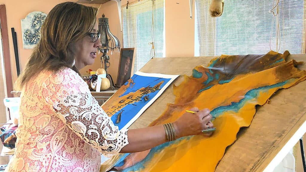
Roots mean a lot to Harley. When the East Coast Greenway Alliance contracted with her to paint a map of the Greenway showing the indigenous people living along its route at the time of European contact, she knew the project was a great fit.
“I like doing anything with maps that brings attention to Native Americans living on the East Coast,” she says. “Usually people only think of the Indian tribes out West.”
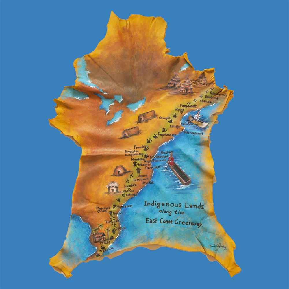
“Highlighting Indigenous peoples through collaborative mapping work is one way to raise awareness about tribal nations. Visitors and residents alike have a valuable new resource for learning about the tribal nations whose territories they cross while traveling the Greenway.”
The East Coast Greenway enjoys a particularly strong connection with the Passamaquoddy tribe at our northernmost point. The Greenway starts just steps from the Wabanaki Culture Center and Museum in Calais, Maine. Passamaquoddy tribal members have sent off a number of Greenway groups over the years with smudgings and blessings for a safe journey.
“As native people, as Passamaquoddy, we welcome the East Coast Greenway as a way to help people connect their bodies, hearts, and minds,” says Denise Altvater, who works with Maine’s Wabanaki Program, “and to better connect them to the beautiful land around us.”
“I deeply value our partnership with the Passamaquoddy people,” says Markatos-Soriano. “They’ve been an important part of so many ECGA events. I want others to get to know them.”
“Any trail, any major road basically started as an Indian trail,” Harley says of mapping the Greenway. In her painting, she has added animal tracks along the route relevant to each region — animals that indigenous people may have tracked and hunted. She begins with moose in Maine and moves south with bear, wolf, beaver, raccoon, wild turkey, rabbit, and alligator tracks. For housing, she painted a cone wigwam/birchbark house in the Northeast, then moving south a longhouse, wigwam, wattle and daub houses (also known as chickee huts). For transportation, she painted a birch bark canoe in the North and a dugout canoe in the South.
Helping Greenway enthusiasts learn more about the indigenous people of the East Coast is satisfying both professionally and personally for Markatos-Soriano. He grew up playing in the forests and creek beds of central North Carolina, where he’d find artifacts such as arrowheads and feel a connection with the area’s earlier inhabitants. “I’ve seen the same interest in my own kids, connecting with that history,” he says. “I would love for people to be surprised and learn more about these indigenous people, then explore further themselves. Go visit the national museum and others sites. Attend a powwow and connect with these vibrant communities.”
Greenway Stories
News, features and more from throughout the East Coast Greenway corridor